"Where can I camp?" sounds like a simple question. On public land in the United States, the honest answer depends on two things most people can't see from the road: who manages the land under your tires, and what that agency printed on a map you probably haven't downloaded.
Bureau of Land Management land is generally open to dispersed camping for up to 14 days. National parks generally aren't. National forests are the interesting case. Many forests allow camping almost anywhere, but a number of them restrict car camping to specific corridors along specific roads, and the only place those corridors are written down is the forest's Motor Vehicle Use Map, a PDF that is reissued every year.
RidgeText now reads the dispersed camping rules from those maps and draws them on a map of the roads near you. Text it a place, and it tells you who manages the land, whether that forest designates camping corridors, which roads near you carry them, where camping is prohibited, and which campgrounds are nearby, then sends that map.
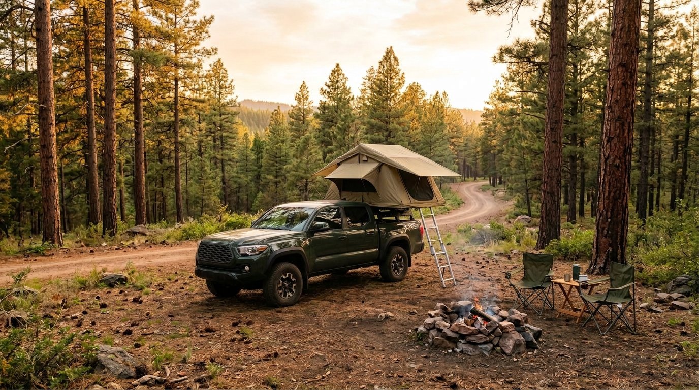
What you can ask
Here are three real conversations, each from a forest that designates where you can and can't camp. First, a quick key to the maps.
How to read the maps
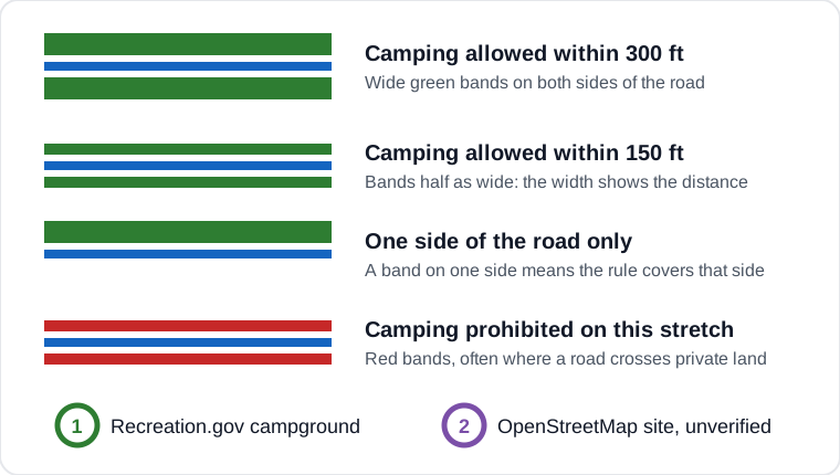
- Blue line: the forest road itself.
- Green bands: where camping is allowed beside that road. They're drawn on the side of the road the rule covers, so bands on both sides mean you can camp on either side, and a band on one side means only that side.
- Band width: how far from the road you may camp. A 300-foot corridor, the widest any of these maps designates, gets the widest band, and a 150-foot corridor gets one half as wide. The bands are a symbol, not to scale, because 300 feet is less than two pixels on a forest-sized map. The reply always states the distance in feet.
- Red bands: a stretch where camping is prohibited, often because the road crosses private land.
- Green numbered pins: Recreation.gov campgrounds. Purple numbered pins: campsites added by the public on OpenStreetMap, which nobody has checked. The numbers match the list in the text reply.
Black Hills National Forest, South Dakota
You: Where can I camp near Spearfish, SD? Show me a map
RidgeText: Near Spearfish, SD, you can find dispersed camping in Black Hills National Forest within 300 feet of designated forest roads like Tinton Road (Road 134) and Higgins Gulch (Road 214).
The reply goes on to list nine campgrounds by number, matching the numbered pins on the map, and ends by asking you to confirm current fire restrictions and forest orders with the local ranger district.
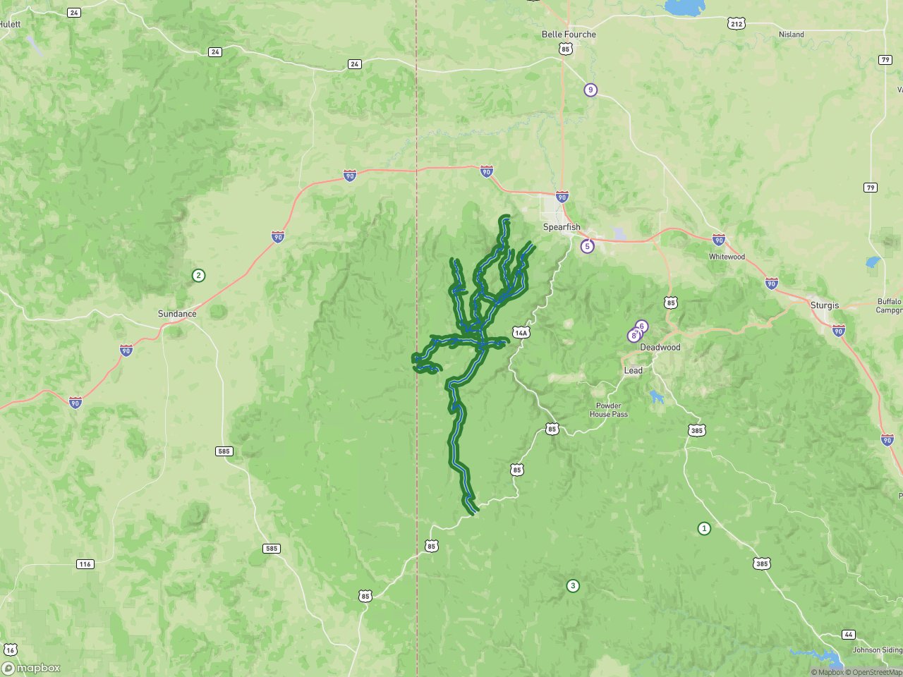
Blue lines are the forest roads. The green bands either side of them are the corridors where the Black Hills map allows camping, within 300 feet of the road. Green pins are Recreation.gov campgrounds, and purple pins are sites added by the public on OpenStreetMap.
Sabine National Forest, Texas
You: Is there dispersed camping near Hemphill, Texas? Send a map
RidgeText: Dispersed camping is available in the Sabine National Forest surrounding Hemphill. You can camp within 150 feet of designated forest routes like Road 100A and Road 1020, subject to motor vehicle use map rules.
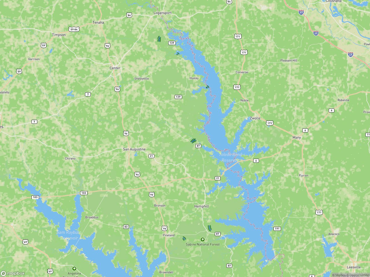
Sabine takes the opposite approach to the Black Hills: instead of a general rule, it lists the individual roads where camping is allowed, 150 feet either side. The short green corridors near Hemphill and along Toledo Bend are those roads.
Gifford Pinchot National Forest, Washington
Most of Washington's national forest land is open to roadside camping, which makes it a poor example of corridors. Gifford Pinchot is the exception worth showing, because its map works the other way round. It allows camping within 150 feet of its roads in general, then lists the stretches of road, by milepost, where camping is prohibited because the road crosses private land.
You: Can I camp along the forest roads near Randle, WA? Show me a map
RidgeText: You can dispersed camp along many forest roads in the Gifford Pinchot National Forest near Randle, generally within 150 feet of designated routes where allowed.
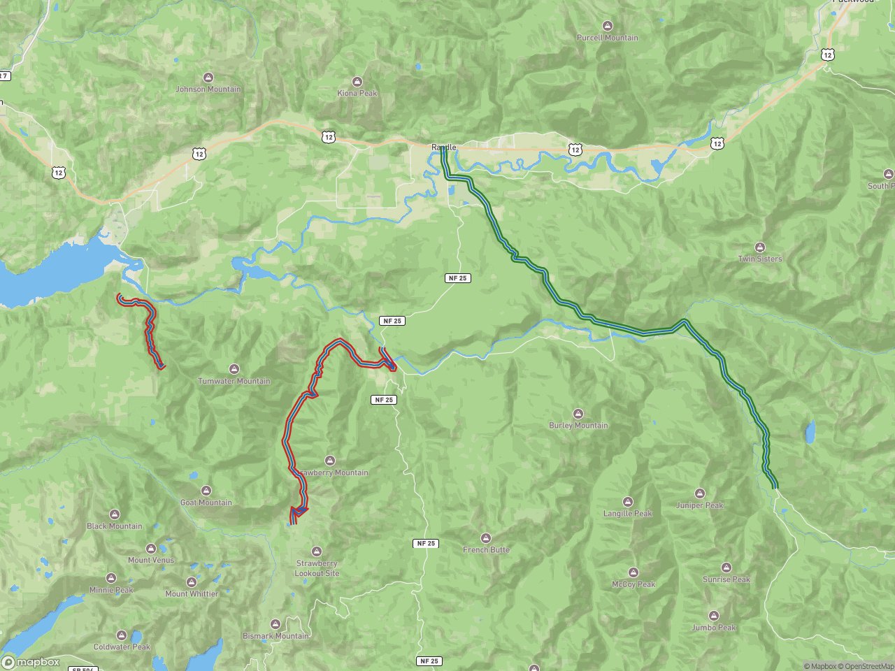
Red bands mark the segments where the Gifford Pinchot map prohibits camping. Green marks a road where it's allowed. Knowing where you can't camp is half the answer.
Where the answer comes from
Each reply combines five sources, because no single one answers the question.
- Who manages the land. The Bureau of Land Management's Surface Management Agency layer says whether the point you asked about belongs to the Forest Service, the BLM, the Park Service, a state, or a private owner, and RidgeText applies that agency's general rule. If the spot itself isn't open, it searches outward for the nearest public land that is. These boundaries are generalized, so RidgeText treats them as guidance, not property lines.
- Which roads are open. The Forest Service's national motor vehicle use map layer has every designated road and trail, with its number, name, district and the vehicles allowed on it.
- Where camping is designated. This comes from the forest's printed Motor Vehicle Use Map, and it's the hard part, explained below.
- Developed campgrounds. Recreation.gov's public data lists nearby campgrounds, and RidgeText checks live availability for the closest three.
- Community sites. OpenStreetMap volunteers have mapped many informal campsites. RidgeText includes them, labelled as contributed by the public and unverified, because a site someone else has camped at is useful, but nobody has checked it.
Every reply ends with the same reminder: designations change with fire restrictions and forest orders, so confirm with the local ranger district before you camp.
The map nobody digitized
You might expect the Forest Service's road data to say which roads allow camping. It doesn't. We checked every field in the national motor vehicle use map layer in September 2026, and dispersed camping isn't in any of them. The designations exist only on the printed map: a table in the margin listing road numbers and distances, or a symbol drawn along the road itself.
So RidgeText reads the PDFs. For each forest, it downloads the current map sheets, finds the camping designations, and stores them as corridors attached to real road geometry. The maps are reissued every year, so the plan is one full pass a year. When someone asks about a forest that hasn't been read yet, RidgeText queues that forest in the background and answers with the land manager's general rule in the meantime, saying plainly that the forest's map hasn't been read.
Most sheets have a text layer, which makes them half easy. RidgeText searches the text for phrases like "dispersed camping" to locate the table, then crops that region as an image. The model reads the table's structure from the image, because tables are visual things, but copies every road number character for character from the text layer, because the text layer can't misread a 4 as a 9.
When the map is a scan
About one forest in seven publishes its map as a scanned paper sheet with no text layer at all, just a picture of a map. These are the sheets where models are most tempted to guess.
RidgeText cuts each scanned page into a three-by-three grid of overlapping tiles and reads them one at a time. Each tile gets one narrow instruction: find any dispersed camping rule on this tile and copy its text exactly. It isn't told what a camping table looks like or where one usually sits. Only after every tile has been read are the transcripts combined and interpreted, in a separate step, into structured rules.
Keeping transcription apart from interpretation is the most important design decision in the pipeline, and we learned it the hard way. An earlier version read and interpreted in one step, and on one scanned sheet it invented two camping corridors out of a table titled "Routes Too Short to Be Seen Clearly." Both inventions passed our geometry check, because the road numbers in that table were real roads. They just weren't camping corridors.
Looking for a table in a specific format is too difficult when every map is different, so we gave the model more freedom to interpret the map and find the dispersed camping notes, wherever they are on the sheet. Then a separate interpreter translates those notes into our database.
Checking against the ground
Every road number pulled from a map is then looked up in the Forest Service's national road layer. If fewer than 60% of a sheet's road numbers match real roads, the whole sheet is rejected and nothing is stored, on the reasoning that a sheet we read that badly can't be trusted for the numbers that did match. The Black Hills sheet matched 192 of its 194 road numbers.
A rejected sheet doesn't become a "no." RidgeText distinguishes three states:
- Designated: the map was read and lists camping corridors.
- None designated: the map was read completely and designates none, so the land manager's general rule applies.
- Unknown: the map hasn't been read, or couldn't be read reliably. RidgeText says so, and never treats unknown as "camping prohibited" or "camping allowed."